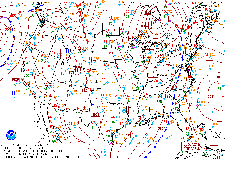
This past Thursday was the first event of the Lake Effect Snow season for areas surrounding Lakes Erie & Ontario. Granted this was not a major event, it was still a recognizable accumulation (1"-5"). There are specific 'ingredients' needed for Lake Effect snow to occur. The fist 'ingredient' is a very cold air mass passing over warm lake water. The magic number for Lake Effect snow to occur is 13. There must be a temperature difference (difference of air temperature and lake temperature) of 13 degrees. The second thing must be a wind direction that crosses a large fetch (wind blows across a great distance over the lake - i.e. for Lake Ontario a westerly flow is best). This westerly flow can be initiated by a synoptic scale even (i.e. low pressure system). On Thursday a cold front associated with a low pressure system passed over Lakes Erie and Ontario which set up a westerly flow and brought cold air across each lake. Above is an image of the system just after it passed over the Great Lakes region.
As stated before, this event did not bring a significant amount of snow to the area but it is important since is was the first lake snow. Areas along Lake Ontario did not see as much snow as areas along Lake Erie because their temperatures stayed warmer. These warmer temperatures brought mostly Lake Effect rain showers to areas along Lake Ontario, along with some mixed precipitation and graupel.
Below is a link to a spotter report released by the National Weather Service in Buffalo, NY from the event:
http://www.crh.noaa.gov/product.php?site=buf&product=PNS&issuedby=BUF&format=ci&version=1
The next chance for Lake Effect snow is Wednesday after a system moves through setting up a period of westerly flow and chilly air. Hopefully it will be an excellent Lake Effect season!